A Rugged GPS Receiver
The first thing you notice about the ColorTrak is its rugged construction.
It weighs in at a hefty 13 oz vs. the Eagle/Lowrance 12 oz and the Garmin
9 oz hand-helds. The battery compartment is securely sealed with
screw-in fastener-sealers. This unit appears well protected for severe
weather operations. As the name says, the screen data is presented
in three colors. There is a rotatable/removable quadrifilar antenna
which provides for a powered external antenna (Part#: 00-19044-000,
price unknown). The antenna connector provides 5vdc to the external
antenna, although the unit operates off of two pairs of AA batteries in
parallel (3vdc). The receiver will operate with just two batteries
installed. The internal battery will not advance the internal clock
for longer than five minutes without batteries installed. Thus if
the batteries are removed for more than about 30 minutes, the unit must
be re-initialized.
The version No. of the unit reviewed is 2.04 (which is not visible at power-up).
To check the version number, press: Menu, Right Arrow, Left Arrow,
Right Arrow, (observe test number '00'), then press Enter. Unit cost
is about $279US and $35US for the data cable. Accuracy is (conservatively)
stated as 25m rms exclusive of SA. Upon detecting no receiver movement,
the receiver automatically goes into an averaging mode in order to refine
its position more accurately.
Keyboard Controls
The keyboard contains the usual buttons on the lower half of the unit with
an up/down/left/right rocker switch. The buttons are easy to push,
but sometime require more than one push to make contact. The NAV
button has the same effect as pushing the rocker switch UP in a NAV screen,
or bring you back to NAV from a menu. There are eight NAV screens
available, but they must be selected in sequence with the NAV button or
rocker switch rather than from a menu. There is a slight (processor?)
delay between each NAV screen.
As with the Eagle/Lowrance, which NAV screen is displayed also determines
what items are available with the MENU button. Most NAV screens are
customizable with a selection from 13 navigation data readouts. All
NAV screens, except the Status and Position screens, can be eliminated
which speeds up considerably selecting only the needed screens. The
Position screen can be alternated with the Lat/Lon screen, both of which
can be user defined.
Waypoints and NMEA
Waypoints are created by pressing the MARK button twice which assigns an
automatic serialized name of 'LMK001' and etc. However, then all
six characters must be edited to create a custom waypoint name. If
the Mark button is pressed only once, the waypoint name can then be edited
by changing as few as one letter. Three variations of NMEA sentences
are selectable: Mode "1.5 APA": APA, BWC, GLL, & VTG
Mode "1.5 XTE": BWC, GLL, VTG, & XTE and Mode "2.1 GSA": APB, GGA*,
GLL, GSA*, GSV, RMB, & RMC*. The (*) indicates sentences required
for real-time tracking by Street Atlas. One push of the PWR button
is all that's required to turn the power OFF; holding the button for some
time isn't needed.
Altitude compensation
One of the most unique things about the colorTrak is its internal pressure
sensor. Nothing about this sensor is mentioned in the manual.
However, our information is that the sensor measures changes in barometric
altitude and uses the information to compensate for apparent altitude changes
due to SA. Thus, WHEN the "real" altitude is known to
be constant or changing very slowly, the apparent altitude error
caused by SA can be partially compensated for. This correction
of altitude error is also used to help correct for horizontal errors
induced by SA WHEN THE GPS IS AT REST OR AT WALKING SPEEDS.
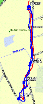
A Walk in the Park


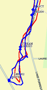
Complete Track
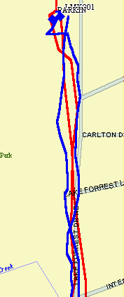
Northern Portion
Southern Portion
This is an attempt to measure the difference in HORIZONTAL ACCURACY (if
any) between a GPS with 'pressure altitude compensation' against one without
it. Above is a walk on a local park path southward from the PARKIN(G)
lot for about a mile to SOUTH and return on the same path.
The red line is from the ColorTrak and the blue line is from a Garmin G12XL.
The receivers were carried at the same time separated as much as possible,
and the map is Street Atlas 5. There were four waypoints created
along the walk simultaneously. The waypoints of the form, LMK***,
are from the ColorTrak and the 'words' are from the G-12XL. The ColorTrak
was set to record a trackpoint every 0.01 miles, and the 12XL was in the
'auto' mode. (The 'auto' tracking mode in the ColorTrak has much
lower resolution than the 'auto' tracking mode of the G-12XL.)
The theory is that with altitude compensation, the effects of SA (at fixed
position or very low speed) can be reduced over those GPS without such
compensation. Looking at the two tracks, one could come to the conclusion
that there really is something to it. On the southern end the G-12
XL had a wider excursion than the ColorTrak, and on the northern portion,
the ColorTrak "track" is straighter and closer to the return track
than the Garmin. Others have also reported more accurate tracks made
while walking as compared to handheld GPS units without altitude compensation.
Related to altitude compensation is a feature of the ColorTrak that provides
a manual setting for either '2D' or '3D' navigation. With 2D navigation,
your altitude (if known) can be set in, thus providing another way to compensate
for SA-induced horizontal errors. Our understanding is that in a
pressurized airplane, the altitude compensation algorithm is effectively
disabled, because the program calibrates the altimeter over some period
of time using regular GPS altitude.
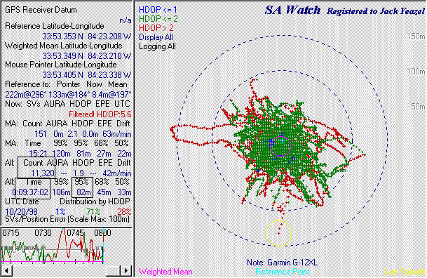
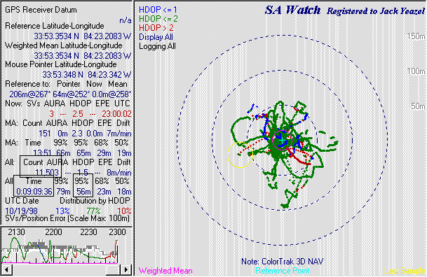
Tests with SA
Watch
This first test run is a picture of a nine hour scatter plot with a Garmin
G-12XL (3.02). Next is a nine hour run with the ColorTrak in the
3D mode, and the last is a run using the ColorTrak 2D mode (see notes at
the bottom of the pictures). (All measurements in a FIXED position.)
The important numbers have been bracketed, Count, Time, and 95% of points
within the indicated radius. This relates to SA's 95% specified
accuracy figure of 100m for the GPS Standard Service. Ninety-five
percent of the points of the 12XL were within 82m of the reference point,
the ColorTrak 3D mode was 65m, and the ColorTrak 2D mode was 37m.
A second run under the same conditions resulted in 79m, 68m, and 32m, respectively
can be seen HERE along with additional testing
under fast-moving conditions. These tests (in the 3D mode) while
MOVING didn't reproduce the SA Watch increased accuracy results, probably
due to the automatic averaging feature not functioning during moving conditions.
Thus, we conclude that the additional accuracy available by the combination
of the CT's altitude compensation and automatic averaging feature is only
available when the CT unit is at rest and perhaps to a lesser extent when
moving very slowly.
Using the average of the two runs (and considering the areas of the measured
circles), the CT 3D readings represent a 32% reduction in errors
compared to the Garmin and the CT 2D readings a substantial 82% reduction.
From past testing and topo maps, the reference point Lat/Lon is known to
within about 5m and the altitude to within about 10m. So, it appears
there is some lessening of the effect of SA with the 3D mode and considerable
lessening with the 2D mode as compared to the Garmin G-12XL.


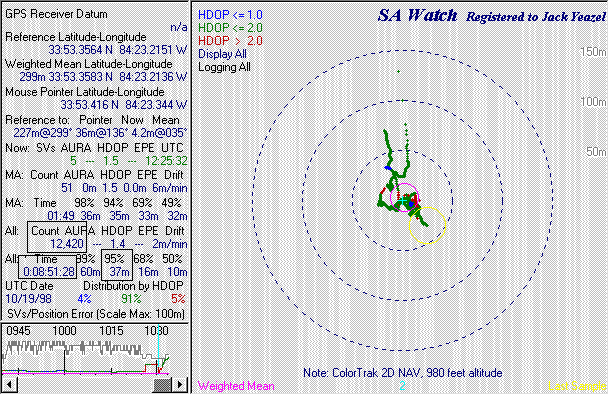
Just looking at the pictures reveals a considerable difference in the effect
of SA on the ColorTrak as compared to the Garmin. The erratic nature
of SA is largely suppressed by the ColorTrak, even in the 3D mode at walking
speeds. This should make hiking tracks much less of a 'drunken walk'
plus some improvement in accuracy. The ColorTrak accuracy on a lake
or ocean stopped or at very low speed should be about the best obtainable
in a hand-held unit without DGPS.
Software Compatibility
Delorme's Street Atlas, Fugawi,
and OziExplorer
all claim to work with the Magellan receivers. However, they apparently
don't (completely) support all the receiver data. Tests with the
ColorTrak 2.04 and the original Street Atlas 5 has shown no ability to
transfer data at all. One must obtain an upgrade from Delorme to
get the Magellan support at:
Delorme Driver. Fugawi can down/upload waypoints, download
tracks, and upload routes to the ColorTrak. OziExplorer can down/upload
waypoints and routes and download tracks from the ColorTrak. OziExplorer,
in addition, supports the 20 ColorTrak waypoint icons. You don't
have to change NMEA ON/OFF mode in order to transfer data with this receiver.
Our information is that (at present) there is no moving map program except
Map-N-Track and OziExplorer that can UPLOAD tracks to the ColorTrak.
Magellan's Map-N-Track is an add-on to Chicago
Map's Precision Map 3 which makes the ColorTrak compatible with PM3,
but we don't have that program to describe how it works. However,
plotting real-time tracks on these moving-map software programs with ColorTrak
in the NMEA 2.1 mode is completely normal.
Some have commented that another program to consider is MapSite
which also supports the Tracker, NAV6000, Meridian, and TrailBlazer.
A puzzling feature of the CT is that after a data transfer, THIS 2.04 receiver
must be turned off and back on in order to navigate. (Earlier versions
don't have this annoyance, but data transfer is limited to 4800 baud.)
Other Features
Battery life is stated as 30 hours, and most have confirmed this.
We found the receiver sensitivity to be good, slightly better than a Garmin
G-III and slightly less than a Lowrance GM100. A separate page
is devoted to Sun and Moon rise and set calculations. Course Projection
is another feature new to us. A selection of 1, 2, 5, and 10 minutes
can be selected. Then a red 'vector' will indicate the estimated
position after that time interval. The ColorTrak has all the alarms
one would need (we think), Anchor, Proximity, and Cross-Track Error.
There are two selectable sets of abbreviations for navigation terms, Land
and Marine. The CT thermometer will readout the internal temperature,
which can be recalibrated if the temperature is known. The CT has
a unique Compass screen. In addition to the usual GOTO or Route Bearing,
Distance, CrossTrack Error, Course, and Speed; the screen also displays
an indication of where the sun and moon are (if above the horizon) which
allows for estimating the direction of north and destination while not
moving. Most items on the Compass screen can be customized.
The CT has a BackTrack function similar to the Garmin's, but unavailable
in Lowrance/Eagle.
A Few Respondent's
Concerns
Some have had trouble with the data cable connector glue failing and the
connector pushing back into the unit.. (Magellan reports this problem
has been corrected in production units as of about September 1998.)
Several thought the key design could be improved. Apparently the
power/data cable must be removed in order to slide the unit into its mounting
bracket. The screen update seems slow; several seconds are required
to display a large stored track and waypoints can be passed before they
are shown as reached on the screen. Several have found the screen
difficult to read without good ambient lighting. While Panning, the
resolution can't be changed. Some have noticed a smoky appearance
to the screen which darkens the display somewhat.
Respondents Like:
The scratch resistant screen face. Quick lock-on. Superior
accuracy. Good feature set. Programmable feature set.
Only two batteries needed in emergency. Sealed battery compartment.
Rugged construction. Sun and Moon information. Best-time-for-fishing
calculation.
Conclusion
If you want the best accuracy possible under some slow moving conditions,
and operate in a difficult environment, the ColorTrak could be your best
choice.
Please let us have any comments relative to errors or omissions in the
review.
Good navigating from Jack
and Joe.