Review by Joe Mehaffey and Jack Yeazel
Revision: 28 Dec 1999
Return to GPS General Information Home Page
 ...
... ...
...Maps
By using the "US Roads and Recreation" CD by MapSource, the user
GPS storage area allows uploading of from 1 to 25 (max) counties into the
G-III+. Depending on area, our experiments showed you could
usually upload 6 to 12 counties (the boundaries of which are
indicated as dashed lines on the GPS) depending on the road density in
a particular area. The counties do NOT need to be contiguous.
In the dense Atlanta Metropolitan area, an area of about 7500 square
miles of residential street-level maps can be uploaded into the 1.4 megabyte
G-III+ user memory, about 65% of the capacity of the Lowrance GM-100.
(Note: The Lowrance GM-100 and the G3+ are "head on" competitors
in the marketplace and we will make comparisons from time to time in this
review.)
Garmin also has a World Map CDROM providing limited road information for the world and also a TOPOgraphical Map version (for the USA only) which provides topo map features. The "outside the USA map detail is substantially less than the USA road detail. (Note: This is because of the very high costs of acquiring accurate and highly detailed road maps outside of the USA. Auslanders should be working on this with your government representatives!).
However, the detail on the new WORLD MAP CD is better (everywhere we looked) as compared with the GM100 world maps. The MapSource WORLD MAP also includes "some" marine navaids whereas the GM100 world maps do not. See comparisons of the Lowrance GM-100, G-III, and G-III+ US and World Maps (HERE). Note: As of January 2000, NO software other than Garmin's MapSource CDROM Maps can be uploaded into the G-III+. This MOST DEFINITELY includes Delorme StreetAtlas 7. (SA7 can be used to upload/download routes, tracks, and waypoints.) Additional features of MapSource uploadable maps are discussed below.
Look and Feel
One of the first thing you'll notice is that the maps are more 'readable'
than the Lowrance MapCreate maps. The major streets are heavy-lined
instead of double-lined making them stand out more and have about 10% more
street-vector resolution. Highways and street names are designated
more often too. 'Creeks' are two-dimensional gray-scale instead of
thin lines. However, this may eat up more memory than MapCreate does
for the same 'creek'. Lakes and rivers are gray-scale in both.
The G-III + Receiver
The new GPS-III + is basically a G-III receiver.
(Click HERE for product review) . Unless noted otherwise,
all features of the G-III+ are the same as in the G-III standard version
and all G-III accessories work with the G-III+. The G-III+ has been
enhanced with additional memory and software to permit the upload of vector
maps from Garmin's new MapSource CDROM Map package. All of the added
memory in the G-III+ is internal as opposed to a removable cartridge.
As with the standard version G-III, no audio alarm is provided.
The G-III+ receiver DOES come with a DATA (only) cable whereas the G-III
kit does not have a cable included.
There are a number of new menus in the G-III+ to support the new mapping features but those familiar with the G-III unit will be right at home with the operation of the G-III+. With the G-III+ you can do the usual G-III route/waypoint/track management, (including TrackBack and MARK) but none of the automated route functions of the StreetPilot are available in the G-III+. MapSource (version 3 and up) and StreetAtlas 7 can be used to upload routes, tracks or waypoints into the G-III+ as in the G-III. G7TO 3.04.04 can be used to up/download waypoints, routes, tracks and screen photographs just as with the G-III.
Other new features in the G-III+
The G-III+ has new features that permit you to locate the nearest
cities and expressway exits. This feature does not recognize major
state freeways (such as Georgia 400) as expressways and only recognizes
Interstate Highway exits with the "nearest exit feature". Airports
and some service facilities are also marked on the new base maps.
The receiver displays 56 waypoint icons as compared to the G-III's 48.
Garmin has removed the firmware revision level from the initial screen so potential customers will not have an easy way to determine which software revision level is in a unit. One must hold down the ENTER key and press the ON key. Software updates should are available on their website as usual for recent equipment. This also gives the diagnostics page. Press QUIT four times for additional information. ON+PAGE clears the almanac, and ON+MENU is an erase of stored GPS calibration and waypoint information!
Battery life in the NORMAL mode on the G-III+ is somewhat more than 20 hours of continuous operation on five different sets of Sony AA alkaline batteries. A "power-save" mode that provides a fix every five seconds as opposed to once per second is supposed to increase battery life by about 30% . (We got 29 hours continuous running in battery save mode.) A new feature in the trip computer allows you to select TOTAL TIME or TIME MOVING TIME for speed calculations. It is possible to turn OFF the MapSource maps and just use the base map if desired.
MapSource CDROM Electronic Maps
(Now
updated to version 4.09)
The Garmin MapSource maps are high quality electronic maps
and the system is easy to understand and use. The USA maps
("Roads and Recreation") are of the same general quality as Delorme
SA5 maps but lack the "tourist interest" and highway detail provided in
SA6. MapSource road accuracy is judged "good" by Jack
and Joe. MapSource maps are more up to date and contain slightly more detailed
water features as compared to the Lowrance CityStreets Maps provided with
the GM-100 family of GPS. (Click HERE for product
review) For a side-by-side comparison of the features of the
G-III+ and GM-100 (Click HERE).
MapSource was designed to provide uploadable maps to the G-III+ and other Garmin GPS products. In addition, starting with version 3.0, MapSource systems provide the ability to: a) upload/download routes, tracks, and waypoints to the GPS, b) allow the user to manually generate a route and upload, c) print maps, d) manually input waypoints and routes onto the map for later upload, e) allows waypoint editing both on the map and in text form. In addition, there are many convenience improvements and bug fixes. Note: MapSource 3.0 is a free update from the Garmin website for purchasers of ANY MapSource product. In addition, prior purchasers of PCX5 can receive an $80 discount on the purchase of any MapSource product since PCX5 is being discontinued as "almost" all PCX5 functions are now included in MapSource 3.0. (Exceptions: Functions which are in PCX5 but NOT in MapSource 3.0x are: 1) DXF export; 2) real-time position plotting; and 3) prediction of satellite visibility and DOP. ) A complete list of MapSource 3.0 improvements and the updated software module can be found HERE.
It is still necessary to use an accessory package such as SA6 for automatic route generation or position tracking on your PC. NOTE: The G-III + *is not* a StreetPilot and it does not have the routing or "address finding" capability of the StreetPilot. Nor does it have the capability to 'LOCK' the GPS tracking icon to the roadway as does SP. So far there is no program like OziExplorer/MapCreate that provides editing the MapSource files.
Waypoint+ and G7TO have the same capabilities with the G-III+ as with the G-III. Richard Bollar has collected a fine group of G-III and G-III+ comparative screen shots. CLICK HERE to see how the G-III and G-III+ with MapSource uploaded maps compare in street detail in Richard's area.
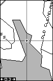
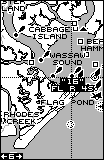
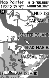
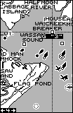
Water Data and Nautical Navigational
Aids
Lowrance has historically included the most detailed water data
in any available low-cost GPS receiver. But a review of the maps
comparing the G-III+ with the GM100 reveals that the Garmin MapSelect has
a noticeably higher shoreline vector resolution than the Lowrance MapCreate.
This is now a reversal of the situation with the GM100 and the G-III.
(Screen shots via G7TO)
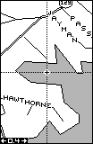
Maps of Lake Lanier Shoreline
Map of a Small Lake Near Joe's House
 __
__
 *
* 
GM100
G-III+
GM100
G-III+
GM100
G-III+
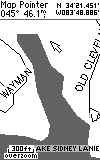
However when it comes to Nautical Nav Aids, MapSource has considerably
fewer than MapCreate and no obstruction markers.
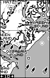
Comparing Nautical Nav Aids of MapCreate
and MapSource near Savannah, GA
(Placing
the cursor over the nav aid reveals additional information.)
 __
__
 __
__
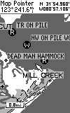
Still, nautical navigational aids in the G-III+ are quite extensive. Garmin informs us that the R&R CD had a few coastal navigation aids, but Water &Lights has a MUCH greater quantity and the W&L nav aids have been checked for accurate positioning. The Water & Lights CD has all the US Nautical navigation aids of daybeacons, radiobeacons, RACONS, fog signals, lights, buoys and other navaids for the 50 states. (This is basically the same marine nav-aids found in the GPS 48). The R&R CD contains inland nav-aids, including boat ramps, marinas, campgrounds, ranger stations, mile markers, first aid stations, etc. (same information as in Garmin's Inland G-charts). (See comparison of inland mile marker, state park and marina icons on Chickamauga Lake near Chattanooga, Tennessee (HERE). The WorldMap CD will have nautical navaids for the entire world.
Fonts and Rectangles
The font size of most all the names in the G-III+ maps can be controlled
except the street-name font. If you notice on the previous map comparisons,
the Garmin street-name font is larger than that of the Lowrance.
The greater number of street names and larger font of the Garmin sometimes
obscures the road at certain zoom levels. By selecting 500' instead
of Auto in the Map Setup, Line, Street Label, this clutter can be reduced
or eliminated.
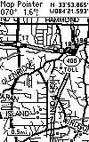
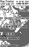
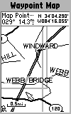
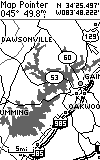
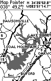
A distraction (to Jack) are the boxes drawn around each county loaded
in the GPS. (See below.) Their purpose is to indicate
what areas have been loaded in the GPS The boxes can't be turned
off when using the G-III+ for navigating. (Joe did not have
any problem with the boxes, so the question of "will the boxes will be
a distraction?" is quite subjective.) See below left.
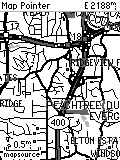
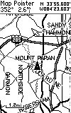
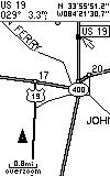
The G-III+ has enhanced BASE MAPS compared with the G-III.
Included are more major city streets, and airport locations.
Many Interstate Highway exit services and facilities are included in G-III
base maps.
"Boxes" around the counties uploaded to the GPS *
Streets and Exit Information added on G-III+
 *
* 
G-III+
G-III
G-III+
G-III
G-III+
Features of MapSource include:
1) Detailed residential street level maps of the entire USA
including Alaska and Hawaii.
2) The user interface is easy to use.
3) The system operates on a Windows 95, 98, or NT environment.
4) Pentium Processor, 16 megs RAM, CDROM drive, mouse, 256
color display, 10 megs hard drive space required.
5) Upload of a selected group of maps (called a "map set")
runs at up to 115kbaud.
6) You can preselect any number of map sets and later select
a map set and upload it.
7) It is easy to zoom in/out and slide the map around ouse
"hand" to view map details.
8) A "find city" feature is provided to permit quick location
of a particular map area.