
The above Vendors support the GPS INFORMATION WEBSITE. Click on above BANNERs for latest PRICES.
RoadMate
760 General Description:
In form and in basic function, the
Roadmate 760 is very similar to Magellan's previous offerings in the
Roadmate family. Street priced at $850 or less (check LATEST
prices
here),
this unit is an advanced car navigator with built-in
street-level maps of the entire United States (including Hawaii), plus
Puerto Rico and Canada. It also includes street-level maps of Europe
(which must be unlocked for an additional fee). It is ready to go
out of the box.
However besides the standard feature set
common to previous Roadmate models, the RM 760 incorporates a number of
sophisticated new features (some of which are not available from any
other company), including:
For reviews of other units in the
Roadmate line, please see our articles on the RM700 and RM500,
the RM360,
and the RM300.
This is a solid unit with a large, bright
touch
screen, great speaker, easy to use controls, and an intuitive
interface.
It comes standard with a windshield mount that is a significant
improvement over the vent-type of mount shipped with previous Roadmate
units (although note that owners of previous Roadmate units can
purchase the windshield mount separately).
Note that the RoadMate units are configured more like an "installed" unit (rather than a unit for the "GPS Enthusiast"), since it has no way to record and download or upload waypoints as with some other Magellan units.
The supplied mapping data from NavTech
seems
fairly complete. The NavTech data appears to be about two years
old (which is about as recent as any comparable unit). The main
navigation screen shows you all the key information at a glance, and
the
voice prompts (and tone prompts for turns) are generally timely and
accurate.
The "repeat" button on the top of the unit provides an update of the
most
recent prompt at any time.
Magellan says that the RoadMates are a
descendant
of the Hertz NeverLost® system where over 4 million drivers have
enjoyed
the ease and confidence of navigating their driving with Magellan
GPS.
It's very user-friendly, and we rate the online manual as average.
What comes with the RM760 kit?
The RM760 comes complete with all of the parts necessary to
mount the unit to your windshield or dashboard and plug it in and
operate in your car.
Included are:
The RM760 does not contain
batteries. Map data and configuration settings are stored on the
internal hard disk so this information is not lost when the unit is
disconnected from power. However the unit cannot be operating in
a portable manner (away from a vehicle or wall outlet) unless the user
purchases a separate battery with an accessory cigarette lighter socket.
The unit has a slot for a compact
flash (CF) card which can be used to store a backup copy of
configuration settings, address book data, previous destinations,
etc. This data will be automatically backed up when the unit is
powered down and can restored if the user should have to reset the
unit. The minimum supported size for the CF card is 16 MB.
A CF card does not come with the unit. Memory for normal
operations and maps is included internal to the RM760.
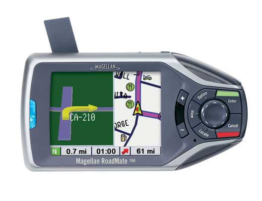
Common Features:
The RoadMate is a well-designed, portable
unit, with a large, bright color touch screen and easy-to-use
controls.
The user controls are to the right of the screen - Enter, Cancel,
Locate,
View, Option surround an 8-way thumb pad, with +/- zoom
buttons.
There is also an IR port between the "+" and "-" keys (which can be
used to transfer addresses from a PDA)
and a light sensor between the "Locate" and "-" keys that is used when
you set the automatic brightness option.
There is a very effective built-in multimedia tutorial that covers all aspects of operation. To run it, press the OPTION key and select TUTORIAL. The RoadMate then provides a very complete tutorial with video and audio describing basic operation of the system. This virtually eliminates the need to access the CDROM manual for normal operation and use.
The RoadMate has about the easiest user
interface
to use we have seen in a car navigator. There are seven push
buttons
for major functions (VIEW, OPTION, ENTER, CANCEL LOCATE, + for zoom in,
- for zoom out) plus a speaker
volume control, repeat voice command key and an OFF/ON switch.
The
RM is designed without internal batteries (similar to the
competitive
StreetPilot 2610/2650) and operates ONLY when plugged into an external
9 to 18 vdc power source. The RM unit automatically turns ON and
OFF with the power application from its external power cord. A lighted
power switch is provided to turn the unit on and off manually as
desired.
'Locate' is used to get a display of the
vehicle's current location (both the street and latitude and
longitude), plus current compass heading and speed. This allows
the location to be saved to the address book, and in the event of an
emergency provides a quick way to tell 911 personnel exactly where you
are.
The unit can be configured to display the
map in north-up or heading-up mode. Additionally, while routing
the unit will display a split view (when approaching a turn) with a
3-dimensional view of the upcoming turn on the left side of the display
and a reduced-size map view on the other.
Operation, routing and re-routing are very fast - much faster than in the Hertz system. If turns are missed the unit quickly recalculates a new route.
The RoadMate was designed from the ground up to economically replace the combination of GPS/Laptop Computer/Mapping Software system that many have used to maneuver around cities in the USA. Roadmate has nearly seven million Points of Interest (USA and Canada combined) and offers a variety of ways for the user to input destinations. The user can input ADDRESSES, select an entry from his ADDRESS BOOK, select from lists of RESTAURANTS, ATM, GAS STATIONS, AIRPORTS, AMUSEMENT PARKS, BANKS, BUSINESS FACILITIES, BUS STATIONS, CAR RENTAL AGENTS, CASINOS, CITY CENTERS, CITY HALLS, COMMUNITY CENTERS and a host of other classifications. Input of Addresses worked VERY well and VERY easily. Restaurant, and Gas Station categories worked pretty well, but we found the listings for some other categories for our area pretty sparsely populated. the quality of the Points of Interest listings does vary dramatically from one area to another. You can also input an address as a road intersection. This selection is preceded by the selection of a City or State to narrow the possibilities.
Another major
feature
is the Trip Computer which provides a running computation on Average
Speed,
Trip Time, Drive Time, and Trip Distance. At any
time,
you can SAVE the "Present Trip Computer Information" in a user named
file
on the hard drive. The user can then revisit this trip log
"snapshot"
at any time by recalling the name.
Now
- How Do I Actually Input an Address?
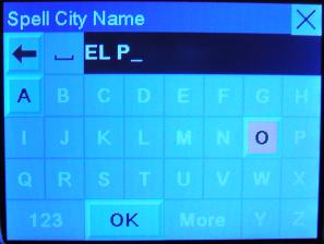
Entering addresses or searching is very easy
with the "quick spell" feature. When you select a letter (by
touching
the screen or using the thumb pad), only valid choices for the next
letter
are available. This makes entering address information very fast.
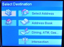
1) Press the View button; this brings
up the options of the Map -or, Select Address, Address Book,
Dining-ATM-Gas,
and Intersection.
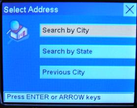
2) Press Street Address, Search by City, spell
the city, select the displayed city, spell the street, spell the street
number.
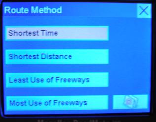
3) Select: Shortest Time, Shortest Distance,
Least Use of Freeways, or Most Use of Freeways.
4) Enter, and the unit calculates the route,
and displays a Maneuver List with all the expected turns
5) Press View to toggle between the map, the
Maneuver List, or turn directions.
6) Press Option to select Trip Computer,
Configuration,
or Tutorial.
7) Press the Cancel button to cancel the
guidance.
Series of operations to route to an
address.
Note that actual display is much better quality than is suggested by
these digital photographs.
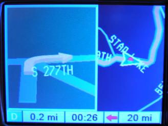
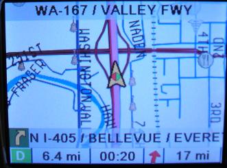
Sample displays. Split 3d/map view on
left appears before turns. Note nighttime color mode.
Right image shows daytime routing mode.
Note that actual display quality is much better than captured here.
Once the route is canceled, its address is stored under: View, Select Destination, Address Book -where it can be retrieved by selecting Previous Destinations. On that page is also List Addresses that have been saved, or Create a New Entry. Information is stored in non-volatile storage and is not lost when the power is disconnected or the mapping data is changed. There is also an IR sensor and a light sensor (used to adjust screen brightness).
On the main map screen, you can zoom to 350 feet, 700 feet, 1/4 mile, 1/2 mile, and then 1, 2, 4, 10, 20, 50, 100, 150, 350, 700 miles. The detail close in was good. Panning can be done with the touchscreen; just touch-and-drag the map. When the map is panned (with either the touch screen or keys), the street names are displayed for those streets not labeled on the map.
When a route is calculated, the main screen shows your location, your current street, and a status lines at the bottom of the screen shows next turn/maneuver, street name, signal strength, direction, distance and estimated time to next maneuver, and distance to destination. You can set the map to always show north and/or scroll, but the default is preferred, which shows your car in the center of the screen. The colored box surrounding the current direction (in the lower left-hand corner) indicates the current signal strength. Black -acquiring position. Blue -WAAS signal (best signal), Green -Strong Signal, Yellow -Average Signal, Red -No Signal. If you lose a signal (red), the unit will automatically switch to the "Maneuver List" view to allow for manual routing and will switch back once the signal is recovered.
By default, the display automatically
switches
to a split 3D/map turn view shortly before a turn is required and will
switch back
to the map and "zoom in" just before a maneuver is required.
Different
tones for left turn ("ding dong"), right turn ("dong ding"), and
keep straight ("ding ding") are used in conjunction with the voice
prompts
to guide you. If you miss a voice prompt, you can hit the repeat
button to update/repeat the last direction. You almost never have
to look at the screen!
Address book data and user settings can now
be backed up to a compact flash card.
New Features:
SayWhere
The 'SayWhere' feature is something many have been waiting for. Although GPS units with spoken turn-by-turn directions have been available for some time now, none (except the recent Garmin SP2720 and Nuvi) were able to actually announce the name of the street the next turn was to be made on. For example, in the course of driving a programmed route, previous units might offer the following voice prompt:
"Approaching right
turn"
However the RoadMate
760 will say,
"Approaching right
turn. South Star Lake Road"
This is a great feature which can
make navigation much easier. My experience with other gps units
is that directions like "turn left in .4 miles" are sometimes ambiguous
in city driving because it can be difficult to judge exactly which turn
the unit is referring to. In those cases it was necessary to look
at the screen while driving. With the 'SayWhere' feature it is
not necessary to look at the screen because the voice tells you the
name of the street.
This feature is not perfect.
The way Magellan has implemented this is to use a recorded voice for
the 'generic' part of the directions. In this example the
'Approaching right turn' is pronounced very clearly and understandably
by a recorded female voice (note that a male voice can also be
selected). The street name however is pronounced in a more
mechanical way. Click here
for an
example. While this works acceptably in most cases, the
computer-generated speech can occasionally be difficult to understand
(especially if background traffic noise is high). Even when it is
understandable, the pronunciation can be awkward. Click here
for another example.
The user can optionally turn this
feature off.
Multi-destination
routing
The RM 760 now incorporates a multi-stop Trip Planner. A
trip is created by clicking on a button in the Address Book
screen. New destinations are added as is done for normal one-stop
routing. When all stops have been entered, the user can optimize
the route (ie. sort it in order from closest destination to farthest).
SmartDetour
The RM760 has a number of options for handling detours:
Screen
Captures:
This option does not appear to work on this unit. On previous RoadMate units, you could capture
screen images as bitmaps to the CF card.
Specific Questions Answered:
Some
notes on performance:
When the unit has not been used for several
days, or when it has moved a long distance (such as when flying to a
destination and then using it in a rental car), it can take an
excessive time to lock onto the satellite signal (10-15 minutes).
This means that you must get your rental car, mount the unit inside,
then take the car to a spot away from buildings, power lines, etc. and
wait for it to acquire the satellites before you can use it to
navigate. The user can speed this process up by manually entering
the new GPS position (Option->Configuration->Diagnostics->Set
GPS Position).
The unit seems to have a bug where if the
unit is on and the user presses the power button to turn it off, but
does it too quickly, the unit will freeze up. In this state the
screen is blank (but very dimly lit), the button backlight is on, and
the unit is unresponsive. Once the unit is in this state the user
must reset it by unplugging the power cord and plugging it back
in. On another occasion a too-quick press of the power button
caused it to continue operating, but without speech. Again I had
to pull the power plug and reinsert it to get the unit to function
normally again.
The unit's receiver is very sensitive (more
than any other gps model I have seen), and I was able to navigate
downtown areas (ie. around tall buildings) successfully. The GPS
signal would come and go intermittently, but the unit was able to lock
on quickly enough to continue to maintain my correct position.
Other GPS units I have used were completely useless in the downtown
area (Garmin 2620, i3).
Previous destinations can now be
deleted. This is an improvement over the RM700/500 series.
Areas
for improvement:
1) Some of the voice prompts do not match
the text on the screen. The text says "Select Address", prompt
says
"Street Address", Text says "Dining, ATM, Gas ...", prompt says "Points
of Interest".
2) There is no way to flag POIs as bad if
the address in the database is incorrect.
3) "Perform the Action" should be context
specific - e.g. on the Cancel Guidance screen, "Yes" choice should read
"Cancel Guidance?" or "Cancel Route?" and "No" should say "Return to
Route"
or "Do nothing" or something like that.
4) The ability to view the map at the
destination
without having to pan (as is possible with Garmin units) should be
available.
5) The unit seems to be very picky
about how the on-screen buttons (ie. buttons which appear on the
touch-screen) are pressed. The user's finger must be centered
squarely over the button to actuate it. This is sometimes
awkward, especially for the 'close' button which appears in the upper
right corner of the touch screen. Along the same lines, panning
the display by pressing and dragging across the touchscreen often has
to be attempted a couple of times for it to register.
6) The map can also be panned by pressing the circular navigation
button, but this is extremely slow.
For More Information
You can find
Magellan's webpage for this product here.
You can download the user manual here.