Garmin
United States TOPO Maps for the G-III+
by
Joe
Mehaffey and Jack Yeazel
(Revised:
6 May 2000 - Add Origin of USA Topo Maps)
The latest Garmin product is topographic data added to street-level maps
that can be uploaded to the G-III+ on three CDs. They are: Alaska/Hawaii,
USA West (Setup), and USA East. Areas to be selected are now rectangles
of various sizes in a grid. Due to the density of the data, only
approximately 1/2 square degree of area (700 square miles) can be uploaded
to the GPS.
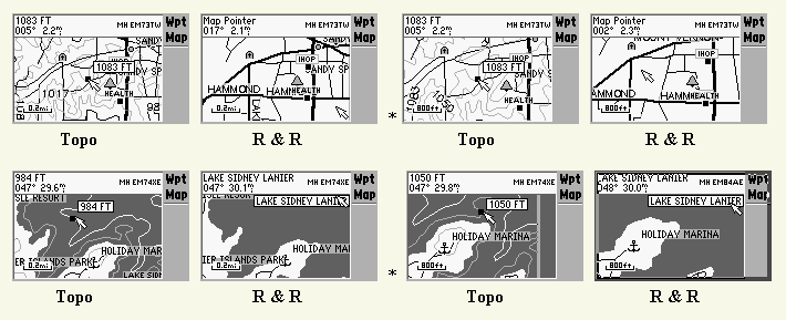
Contour lines are at 10m to 50m intervals in the Atlanta area depending
on zoom level and 20m intervals in more hilly terrain of North Georgia.
In mountainous areas of Oregon the contour lines are 40m intervals.
On the larger lakes, elevation contours (not depth contours) are also shown.
(Samples shown below).
The CD-ROM maps are similar to U.S. Geological Survey 1:100,000-scale topographic
paper maps. The data contains highways, roads, hiking trails, snowmobile
trails, backwoods trails, elevation contours, point elevations,
summits, some bathymetric contours, geographic names, churches, and schools.
Shoreline detail is included for lakes, reservoirs, small bodies of water,
waterways, rivers, and streams. Icons represent boat ramps, dams, marinas,
campgrounds, public facilities, mile markers, first-aid stations, picnic,
swimming, and ski areas, wrecks, fuel, and dangerous and restricted areas.
In addition, nautical navaids for the 50 states are provided, including
radiobeacons, RACONs, fog signals, river, harbor, and other lights, daybeacons,
and lighted and unlighted buoys. Wrecks and obstructions such as shipwrecks,
submerged rocks, obstructions and other hazards to nautical navigation
are displayed.
Gamin has advised us that the database is older than that in the Roads
and Recreation CD, and therefore some streets shown in the R&R
CD will not be shown on the Topo CDs. (An example of this is also
shown below.)
The small stream data is about as extensive as possible with some streams
traced back to the spring they come from! Where the Lowrance MapCreate
CDs have more small stream data than the R&R CD, the Topo CD now surpasses
that. An oddity with MapSource is that when the program loads, it
immediately minimizes itself to the task bar. One must download MapSource
update Ver. 3.xx from Garmin to prevent this.
See origin of USA Topo Data(HERE)
Additional Garmin Screen Captures of the Topo CDs are shown (HERE).
Now you can keep that propeller off the rocks -and not fall into the ravine!