Magellan Model 315 GPS Receiver
A Review by
Joe Mehaffey and Jack Yeazel
Return
to GPS General Information Home Page
Revision: 31 August 1999
Magellan 315 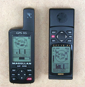 Garmin
12XL
Garmin
12XL
A Compact GPS Receiver
The first thing you notice about the M-315 is its small size and light
weight. Where the ColorTrak weighs a hefty 13oz, the 315 weighs only
6.5 oz. The comparable Garmin G-12 weighs 8.7 oz. The unit
only requires two AA batteries as compared to four for the Garmin.
The two units are approximately the same size, however the M-315 has a
higher resolution screen. See Dale DePriest's comparison table of
these two GPS receivers (HERE).
NOTE: In the above photo, the M-315's fewer Sat bars is due to it
lying on its back, not the optimum position of straight up. Both
receivers receive the same number of Sats in their optimum position.
The firmware version No. of the unit reviewed is 1.03 (which is visible
at power-up). Unit cost is about $150US and $39US for the data/power
cable. (Check
latest prices HERE.) Accuracy is stated as 15m rms exclusive
of SA. Upon detecting no receiver movement, the receiver automatically
goes into an averaging mode in order to refine its position more accurately.
A feature not seen in any other GPS is, "The best time for hunting and
fishing".
Keyboard Controls
The keyboard contains the usual buttons on the lower half of the unit
with an up/down/left/right rocker switch. The buttons are easy to
push, and are an improvement over the ColorTrak. The NAV button cycles
the navigation screens in one direction, and the QUIT button cycles them
in the other. There are seven NAV screens and two Position screens
available, but they must be selected in sequence with the NAV or QUIT button
rather than from a menu. A slight processor delay between each NAV
screen in the ColorTrak has been improved in the M-315.
As with the Eagle/Lowrance, which NAV screen is displayed also determines
what items are available with the MENU button. Some NAV screens are
customizable with a selection from seven navigation data readouts.
All NAV screens, except the Status and Position screens, can be eliminated
which speeds up considerably selecting only the needed screens. The
Position screen can be alternated with the Lat/Long screen with the Left/Right
rocker. The latest version of the M315 firmware allows panning and
zooming at the same time. While in pan 'n scan mode is now possible,
by pressing the ENTER key, to cycle through the zoom levels.
Compass Screen
The M-315's compass screen contains a unique display of the sun and
moon positions (when above the horizon). With this information, one
can point the sun icon to the sun (or moon icon to the moon) and determine
true north without the necessity of moving or using a compensating compass.
Waypoints and NMEA
Waypoints are created by pressing the MARK button twice which assigns
an automatic serialized name of 'WPT 001' and etc. However, then
all six characters must be edited to create a custom waypoint name.
If the Mark button is pressed only once, the waypoint name can then be
edited by changing as few as one letter. Three variations of NMEA
sentences are selectable: Mode "1.5 APA": APA, BWC, GLL, & VTG
Mode "1.5 XTE": BWC, GLL, VTG, & XTE and Mode "2.1 GSA": APB, GGA*,
GLL, GSA*, GSV, RMB, & RMC*. The (*) indicates sentences required
for real-time tracking by Street Atlas. One push of the PWR button
is all that's required to turn the power OFF; holding the button for some
time isn't needed. Data Send (see below) corrects for a bug in the
Small Cities POIs included with the GPS where the Closest aren't correctly
listed. All POIs can be sorted Alphabetically or Nearest. You
can attach comments to up to 100 waypoints in the unit.
Software Compatibility
This version of the M-315 can exchange and store data with Street Atlas
6 (with the "deldmcgps2.exe"
fix), OziExplorer, Map-N-Track, and possibly others. Ozi seems
to have the most compatibility. With Ozi, one can download Garmin
waypoints and comments, and then upload them to the M-315. All 20
M-315 icons are supported by Ozi. Ozi and SA6 can download and display
tracks from the GPS. Ozi can upload them back to the GPS, but SA6
can not. However, SA6 can be used to calculate a 'quickest'
route that can then be uploaded to the M-315.
Data Send
The Data Send CD ($39US) allows one to select from 500,000 Points of
Interest (POIs) in 35 categories and upload up to 20,000 of them to the
GPS. Extensive information is also contained in these POIs. The CD
we evaluated is North America Ver. 1.0. The program presents a world
map which should be zoomed to a "Region" of interest. The exact region
to contain the desired POIs is defined by a 'drag-down' rectangle.
Once the categories are selected, they are displayed on the map (with or
without icons and names). Then by pointing at the POIs, additional
information is shown to the left (see below).
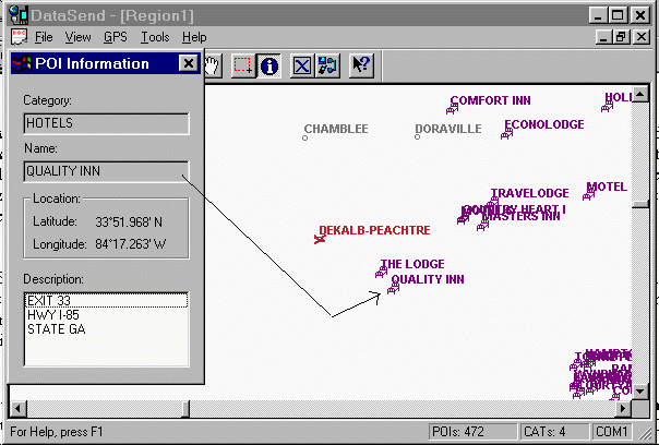
Even more information (addresses, telephone numbers, bearing and
distance, for example) are displayed when POIs are selected in the GPS
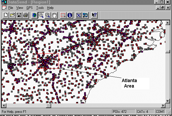
itself. One thing that slows the program considerably, is that it
downloads ALL the POIs on the CD for each category selected and not just
those in the red-rectangle of the desired enclosed region (see next).
However, only the POIs in the enclosed region are uploaded to the GPS.
2-D Navigation
For stationary tests, we used the data-logging program
SA Watch to run two 10-hour averaging tests over a reference point
known to within 10m horizontally and vertically. The 3-D test resulted
in 95% of the points to be with 65m of the reference point, and the 2-D
mode showed 95% of the points to be within 49m -a 25% improvement.
Other Characteristics
The battery drain was measured as 145ma with regular alkaline batteries.
This would indicate about a 12-hour battery life (or 24 hours for four
AA batteries normally required in the current GPS units).
Pinout: If you look at the back of the unit's contacts and number
them from left to right as 1,2,3,4 then:
315 Contacts
Other connections
1 = Data in (pin 3 on DB-9) yellow
wire.
2 = Regulated 3.86vdc, red wire.
3 = Ground (pin 5 on DB-9) and
ground on cigarette-lighter plug, black wire.
4 = Data out (pin 2 on DB-9)
orange wire.
The M-315 with its small size, light weight, sturdy construction,
clear and detailed screen with many available point of interest should
be one of the most popular GPSs of the year.
Please send corrections and comments to Jack
Yeazel