Product Review by Joe Mehaffey and Jack Yeazel
(11 Feb. 2000 - Describe Waypoint Creation Procedure)
(2 Sept. 2000 - CAVEATS Updated to Reflect Newest Ver. 2.52)
 The
eMap Mission
The
eMap Mission
The
eMap Mission
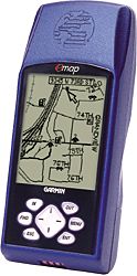
The eMap is Garmin's entry into the LOW COST mapping GPS receiver. Garmin's other entries into the MAPPING GPS RECEIVER market have been GPS-175/G-III/G-III+/G-12Map. The maps in these earlier units were not what most people wanted in their GPS designed for use in their automobiles or walking. With the introduction of the StreetPilot (SP) road mapping GPS with its Etak METROGUIDE MAPS this situation changed, BUT at a high price. Typical street prices for the eMap (no memory cartridge) are in the range of $200. With an 8 MB cartridge, about $250. With a 16 MB cartridge, about $335. A blank 16 meg cartridge is about $145 purchased alone. Street prices are down. Check latest prices (HERE.)
Garmin has changed the price point for a high definition residential street level mapping GPS receiver with the introduction of the eMap receiver. If you are looking for a simple to use, low cost mapping GPS receiver with excellent maps and a highly readable map screen, and a reasonable feature mix for lots of applications, you will be pleased with eMap. If you are looking for a full featured mapping GPS with ALL standard features for hiking, boating, or flying use, including being robust and waterproof, you will want to look at other models. Emap comes with a built in BASE MAP covering 100% of the Federal highways plus all major state highways. Optional 8, 16, 32, 64, or 128 meg memory cartridges permit the uploading of additional maps from Garmin's MapSource CD ROM map product line. (Note: Like other consumer GPS receivers, it is not possible to upload DRG, TOPO!, Delorme, or any other maps not provided by the GPS manufacturer into eMap.)
What's different about eMap:
The eMap is a NEW KIND of GPS receiver system. It's basically a "shirt pocket size" GPS with simplified controls and features, far fewer than in "ordinary" GPS receivers designed for hiking, boating, or aviation. Instead, eMap is designed to be an ELECTRONIC MAP with a mid sized high resolution viewing screen. It is designed to replace the paper map we often use for automobile navigating. Best of all, eMap can load the MapSource MetroGuide, WorldMap, USA Topo, and Roads and Recreation CD maps into its 8 or 16 megabyte optional memory. MetroGuide maps are the most complete and most accurate electronic road maps for the USA that we have seen. For comparison of the different features in MapSource MetroGuide, Topo and R&R maps go HERE.
Instead of EPE (Estimated Position Error) there is a measure of "Accuracy". There is no provision for automatic address-to-address routing. However, you can "FIND" a specific address if MetroGuide maps are loaded and eMap will point it out to you on the map. Although the eMap series is the first to record ALTITUDE in waypoints and tracks, one must navigate to the embedded Satellite Page to see real-time altitude displayed. As for map display, the eMap doesn't clutter up the map or interfere with street lines with uploaded map boundaries at zoom levels less than 30 miles.
Display screens missing from eMap but available on most general purpose Garmin GPS receivers include: HIGHWAY SCREEN displaying cross track error, NUMERIC SCREEN with "compass" display, and COMPASS ROSE screen with numeric display. The eMap is not rated submersible (or even water resistant). Keep it dry or failure is likely.
TRACKS, including the compressed tracks, can be used as routes by employing TrackBack in eMap. The MAP screen, which strongly resembles the StreetPilot screen, is the only navigation screen provided. eMap has more pixels and bigger than on G-III+/G-12Ma. On eMap, none of the numeric screen displays are user changeable. (Unlike other Garmin units where almost all numeric displays can be selected and changed by the user.) The familiar satellite page is now embedded under six keystrokes. ROUTES function some differently than in other models. While traveling, there is an arrow pointing in the relative direction to the next routepoint. When stopped, the arrow changes to the numeric bearing and distance to the routepoint
CAVEATS: The eMap's track resolution isn't adjustable as in the G-III+. Timed, Distance, and Resolution logging of tracklog points is not available. Therefore one must use whatever default logging parameters the eMap has. However, with Ver. 2.52 the tracklogging of walking trails is greatly improved. Gone is the threshold limit of 1m/Sec (2.3 mph) needed to create a trackpoint.
Therefore a simultaneous test was performed with the eMap 2.52 and a G-III+ with its Resolution mode set to 10 feet. During the walking part, the G-III+ didn't record ANY trackpoints! But the eMap recorded a fairly nice figure-8. Upon driving a short distance at about 5 mph, the G-III+ actually recorded more trackpoints than the eMap, indicating that the Resolution in the eMap is something greater than 10 feet. A second test was made with the G-III+ Tracklog Interval set to 0.01km. This setting resulted in a higher-resolution walking track than the eMap. See graphic of walking and driving tests (HERE).
With Ver. 2.60, the tracklog resolution was greatly increased. This new increased resolution came with a price. City driving filled up the Active log in about 100 miles while walking filled the log in about 5 miles. Now with Ver. 2.61, the resolution appears to be back to the 2.52 level. See examples (HERE). The walking Active tracklog limit now seems to be about 30 miles, and the city-driving limit is about 150 miles. For those that would like to experiment with Ver. 2.60, it is available (HERE)
MAP MEMORY and External Connections:
eMap has an optional 8 or 16
megabyte memory cartridge which is necessary to use the map upload feature.
Unfortunately, eMap loads MetroGuide maps in 8 megabyte sections. Each
8 megabyte map section encompasses about 15,000 square miles (in the Atlanta
area). Two map sections can be loaded into the 16 megabyte cartridge.
(Since this is common to all Garmin memory card receivers, we think it
would be more useful to have MUCH smaller map sections.)
With eMap you can upload a maximum of 99 "map sections". A MetroGuide 8 meg map counts as a section and so does a 100 kb or 400 kb MapSource R&R map "county" count as a section. This change from 50 (prior to ver 2.50) is a significant improvement for many. It was easy to hit the 50 map section limit before you got to 16 megs and the new 99 map section limit should eliminate this problem. The reasons you might want a 16 meg memory cartridge are: You want to load 2 MetroGuide map areas, or you want to load a MetroGuide map area PLUS (up to) 98 MapSource R&R "counties" including perhaps some TOPO sections and perhaps some World Map sections.
eMap has external connections by yet another proprietary Garmin connector. External power should be regulated at 3.15volts +/- .15 vdc according to Garmin. The Adjustment for map contrast is made by pressing and holding the backlight control. One must then press ENT for any changes to take place. Backlighting only has one setting.
eMap's Features:
When using MetroGuide maps the eMap provides "RoadLock" whereby if your track crosses a road and are moving 15 to 25 mph along the road, then your current position icon will "lock to the road" thus eliminating (for street travel users) much of the effects of GPS position error. When used with any MapSource R&R or TOPO map, "roadlock" does not operate. When the position icon is locked to the roadway, the accuracy circle disappears. When not locked, you have the accuracy circle in view. (Note: A few users have commented that roadlock occasionally causes your position to lock to a street when you are actually motoring along an adjacent parallel street. We find this a very minor problem as it is always obvious which street you are actually on.) This road-lock feature can be turned OFF or ON as in the SP(CM).
ROUTES: In addition to uploading maps, ANY MapSource CD map can be used to generate waypoints and a route which can be uploaded to the 50 routes available in eMap. While these features are similar to the StreetPilot (SP) models, the routes do not "rubber band" to the roadways and there is no "turn coming up" audio indication as produced by SP. With eMap (and using either MetroGuide or Mapsource maps, unlike with SP and ColorMap) the route from A to B is a series of straight lines with waypoints at intersections. YOU look at the eMap and decide based on the display and the pointing arrow where to turn by relating your current position to the next turn
If you were to buy the MetroGuide USA maps, you could us MapSource to automatically create a route and upload it to the eMap. The eMap would only draw straight lines between turns, but the unit would give you the distance, time, and direction to the next turn. Before the turn, the unit would beep, and the big direction arrow would show the direction of turn -and finally the name of the cross street. But that's all.
With eMap, map data can be uploaded at 115 kbaud rate if your computer serial port supports this rate. eMap provides a high resolution (120x160 pixels and 1.7"x2.2") display which is easy to view in daylight or with the single level backlight at night. Lighted keys would be handy for night use, but eMap omits this feature. The case size is 5.5" x 2.37" x .8" (6x14x2 cm) which thickness is considerably less than any GPS we have reviewed. It makes a comfortable shirt pocket fit.
The eMap is rated "water resistant" (IPX2). We would be apprehensive about the unit continuing to work if it got rained upon. The case has clean lines and looks generally well built. However, the battery cover is quite thin, not captive, and the eMap case appears to lack the robustness of other Garmin receivers. The temperature range is 5F to 158F (-15C to 70C) which is quite a wide range. The weight is about 6.7 oz (197g) and is considerably lighter than other Garmin models. It is one of the lightest mapping GPS we know of, and this is in no small part because it runs on just two AA cells. Battery life is rated at "up to" 14 hours. We measured 130 ma battery drain confirming the rated life. The unit draws 60 ma in the "Indoor" mode indicating about 30 hours life in that mode.
Other eMap features include: Trip Computer (Trip Odom/Stopped Time/Moving Avg. Speed/Moving time/Overall Avg. Speed/Total Time/Max Speed/ and Total Odometer), Route Pointer (on Map page only), Mark Waypoints, Direction to Next RoutePoint and speed/distance to go/time to go (map page option) are available. It is possible to have the GPS to FIND any of the following map features: waypoints, cities, freeway exits, Points of Interest, Street Addresses (i.e.: 300 Spalding Dr., 30328 requires MetroGuide Maps), and road intersections. As many as eleven TRACKS can be stored, The ROUTE feature can be used to manually put together a route from user waypoints. We especially like the ability to FIND an individual residential street address and point to it on the map. Not automatic routing, but very helpful. There is no simulator mode in eMap. For Master Reset of All User Data, press ON plus ESC.
Ver. 2.50 Feature Updates: A list of the 24 updates can be found (HERE). Some updates aren't "self evident", so here's an explanation for some of them. Others will be added as we understand them ourselves!
Multiple routes (1000 map points and 500 user waypoints
in up to 50 routes with up to 50 points each):
Map Points are created when you point to an object in the built-in basemap
or MapSource Map data while creating a route. (Examples are interstate
exits, cities, and airports. They require less memory to store than
a waypoint. Map points are not listed in the waypoint list.
This should not be confused with the "Save as Waypoint" function.
When you point to an object on the basemap, and choose Save as Waypoint,
the data is actually translated to a waypoint. It will now take more
memory and be listed in the waypoint list.
Memory gauge on the main menu page: The
memory gauge indicates the level of all non-volatile memory in the eMap
(exclusive of data cards). User-controlled items in this memory
are waypoints, map points, routes, and track logs.
Limit waypoint identifier names so that the NMEA
sentence lengths are not exceeded: Waypoint
names can be longer than the NMEA specification allows on output.
The names are now truncated when necessary to limit the NMEA string
length to specifications. The problem actually is most likely to
occur with Map Waypoints where their names could be as long as 50 characters.
Added Stored Without Batteries option on the Poor
Satellite Reception page: After
several weeks without batteries, the real-time clock will stop running
but the current time will still be recorded for a few more weeks.
Autolocate may be required to find visible satellites. If the user
selects "stored without batteries", the unit will switch to autolocate
and ignore the stored time.
Show Next Street option:
Provided: you have a MetroGuide map and there is road-lock, then
with this item selected, each cross or side street coming up will be noted
in the box. Nice for locating side streets in the DARK!
Added A800 PVT data output capability:
This feature allows programs like Street Atlas 7 to exchange data and perform
real-time tracking without changing out of the GARMIN mode.
Added Sun and Moon page:
This page is similar to the Magellan sunrise/set, moonrise/set page, except
that the GPS also shows the phase of the moon.
Numeric Directions: The
compass rose on the map page doesn't have a numeric capability, but all
waypoints displayed with the "Find" function can show either a numeric
or an 8-cardinal bearing and distance to the waypoint from present position.
NOTE: With
Ver. 2.70 or later, road lock can be turned off or on.
Software Compatibility:
It is not currently possible to upload maps from any NON-Garmin map collection. MacGPS Pro, Ozi Explorer, and Street Atlas 7 and many other map programs can take the current position from the NMEA output and display it on a moving map.
Data Exchange:
eMap includes a new 'altitude' data field in the eMap protocol (Garmin HOST mode) for waypoints created at the present position marker. The programs that can currently read this data field are MapSource 3.x, G7ToWin, and MacGPS Pro (MAC computers ONLY). MacGPS Pro will also transfer Almanacs, Waypoints, Routes, and Tracklogs in both directions, to and from the eMap, using the new protocols.
Ozi Explorer data exchange is now reported to be completely compatible with eMap. G7ToWin has been rewritten to provide both down and uploading waypoints, routes and tracks to the eMap for versions A.00.02 Beta 19 and above.
Street Atlas 7 can upload Draw Objects (waypoints) and Routes to the eMap and can download waypoints and tracks to SA7. This requires the latest version of Delorme's SA7 updates.
Waypoint+ can upload waypoints from WP+, but cannot download waypoints to WP+.
Major features shared with other Garmin models:
eMap includes a USA base map with all federal and state highways and with many smaller numbered state roads. As noted above, it is also possible to upload much more detailed maps from Garmin's MapSource collection. The World overview map display, road map display, trip computer (includes maximum speed, average speed, trip timer, odometer, etc. are similar to other garmin mapping GPS models.. As with the G-III(+), one approximately 2000 point tracklog is provided along with 10 compressed tracklogs having about 250 points each. If you use MetroGuide Maps, you will also "by default" have "road lock" turned on which will lock your track to a road if you are within perhaps 500 feet or so of a road. This could be disconcerting if you were hiking and were NOT on a road. With the coming of ver 2.50 firmware, eMap now has a wide range of datums and includes UTM capability. Position pinning (where the GPS stopped showing motion if the speed got below about 2mph) has been removed and eMap now works like other Garmin units in this regard.
Major features NOT shared by eMap with other Garmin receivers:
The Satellite page doesn't appear at startup. One must press: MENU > MENU > Main Menu > 'GPS Info' page, which shows SVs in view, signal strength, altitude, speed, Lat/Long, and 3D or 2D mode. The 'System Info' page gives the firmware revision, and the 'MapSource Info' page lists all MapSource map sections loaded into the GPS. Each section can be selected to be displayed or not displayed. All numeric displays fields are fixed position and none are user selectable. eMap has 500 user waypoint capability plus 50 routes with 50 routepoints. In addition, eMap has 1000 "map points" which can be used "like waypoints" in many cases (see above description). The "highway page" display as in other Garmin receivers is not present in the eMap (This is mostly useful in marine and aviation applications.)
The external antenna port requires an external antenna capable of working with a 2.5volt DC input. Most (if not all) current production 5 volt amplified antennas will not work. eMap has an external antenna port using a MCX connector with which the Garmin's GA-27C antenna is compatible. Tri-M's new Mighty Mouse II antenna operates from 2.5 to 5.5 volts and draws only 5ma. Both the GA-27c and the new Tri-M 2.5volt antennas will work nicely with eMap and G-12Map, both of which output 2.5 volts to the external antenna connector, as well as all other GPS receivers which provide 2.5 to 5.5 volt power on the external antenna connector. Battery timer- The eMap has no battery timer feature. It does have a battery "fuel gauge" and "memory gauge" display.
Seventy-five ICONS are available in eMap to identify user waypoints and mark routes. A half inch compass rose provides direction of movement indication. This compass rose is replaced with a NUMERIC BEARING to next waypoint when ROUTE is being used. The battery meter operates properly only for Alkaline batteries. Alkaline battery life in the eMap (2 AA cells) is about 14 hours compared with about 28 hours for the G-III+ (with 4 cells). (Backlighting substantially reduces this battery lifetime.)
Features and Operation:
Basic functions in the eMap are similar to those in the StreetPilot. However, many functions are quite different since the eMap is a reduced feature unit. The eMap incorporates the same 12 channel PARALLEL GPS receiver design used in the G-12XL/G-II+/G-III/SP products. Like these, the eMap locks on to the SV signals quickly and works well in moderate tree cover similar to other Garmin units. "Warm starts" are typical in 20 seconds. "Cold Starts" after 3 hours off time take 50 to 70 seconds. In AutoLocate after a 1000 mile UPS trip, the G3 locked on in less than five minutes. Specifications are "warm start", 15 seconds, "cold start" 45 seconds, "AutoLocate" 5 minutes. These times are typical of 12 channel parallel receivers in the clear and not moving, but a bit slower than the G-III+ in our measurements.
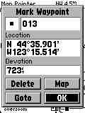
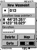
Creating waypoints at the map pointer isn't described in the manual. The procedure is to move the pointer to the desired location and press ENT 'briefly'. Pressing ENT for one second will create a waypoint at present position no matter where the pointer is. These screen shots shows the difference. Note that altitude isn't recorded at the pointer location. NOTE: If you place the cursor on an "object" such as a road, POI, railroad or such, then you must press ENT, then press MENU, and you will find that (in version 2.05 firmware) you have a new option called "Save as Waypoint.
If the eMap is shielded from SVs (and thus unable to lock) for a time, the unit will request initialization. With Garmin's "Initialize by Map" feature, you do not need your approximate Lat/Long to speed up the initial lock when you move more than 300 miles with the unit off. Simply point at your approximate location on the map and press "enter". If you "don't want to mess with it", you can select AutoLocate and it will figure out where it is in minutes all by itself. In a moving vehicle, expect lock times to be longer due to flutter and multipath on the GPS signal.
The eMap's specification for position accuracy is 15 meters exclusive of SA and 5 meters with suitable DGPS correction signals. These are the same as the G-12XL, G-II+ and the G3. This specification is typical of Garmin's 12 channel equipment line. The eMap has Garmin's "dead reckoning" feature which, upon loss of SV signals, will project a course for 30 seconds along the last valid heading. This reduces the impact of momentary loss of GPS signals at underpasses, tree cover, and city buildings.
Position averaging is available in the eMap. (Press MENU on the MARK WAYPOINT page to activate.) To improve accuracy, the eMap (like other Garmin 12 channel units) uses an over determined solution when more than 4 SVs are locked. This produces somewhat higher accuracy than units which use only the best four SVs. Garmin uses an algorithm that gives varying "authority" to measurements from SVs depending on their geometry, and other factors. This may be responsible for the relatively good accuracy of Garmin's 12 channel parallel receivers.
The eMap operates from 2 AA batteries or from 3.0 volt nominal external power. This requires a voltage regulator in the power cable to avoid destruction of eMap. Battery drain varies substantially as battery voltage drops. Power drain is about 340 milliwatts typical. We get about 14 hours from a set of 2 Toshiba/Sony Alkaline AA cells. This battery life is about 50% of late production G3+ receivers, but with 2 cells instead of 4. The LED backlit display lighting has a rated design life of 100,000 hours. The eMap shuts down when the internal battery voltage goes below some set voltage. Only an alkaline battery profile is provided by eMap and other battery types were not tested.
The data/power cable uses a new proprietary connector design which appears quite functional, but it is NOT as robust as the connector system in other Garmin models. The external antenna connector, a MCX female coax jack, is located on the right rear of the unit just behind the built in antenna. The MCX jack is powered with 2.5 vdc and has a current limit rated at 50 ma to protect the unit from shorts on the antenna cable. The Garmin GA-27C and TriM MM-II amplified antennas are the only antennas currently rated to operate at directly with the eMap. However, the GA-26C antenna with a BNC to MCX adapter will also work.
The eMap outputs NMEA protocol NMEA-0183 ver 2.0 or Garmin's proprietary GARMIN HOST protocol, and accepts DGPS input protocol RTCM-0104. eMap includes the following data transfer modes: GARMIN HOST, Garmin Beacon receiver, NMEA OUT, Text Out, and several RTCM (DGPS) combination modes as well.
Subjective Observations of Performance:
Jack Yeazel and I have tested the eMap and find it has similar accuracy and performance capabilities as other Garmin 12 channel receivers. Our eMap has worked properly at all times. All map programs tested which specified a NMEA-0183 ver 2.0 data stream as input tracked properly with the eMap. The eMap laid down smooth tracks on our highway maps during all tests. No gaps, jumps, etc.
We noted that the eMap (along with the G-12Map and the G-III+) have a form of "dead reckoning" for moments when signal dropouts occur. For instance, if the eMap is tracking along and just before a sharp turn you invert it and block its antenna, it will continue to track straight for about 30 seconds. It also provides a very good data smoothing filter to throw out random fixes that are way off track. This results in an exceptionally smooth track on a moving map display. Even with this filter, there was no overshoot apparent during quick stops, sharp turns, and similar maneuvers when normal continuous tracking was taking place.
eMap's performance under tree cover and city canyon conditions was about the same as the G-III+, G-12Map and the NavTalk and we rate that as very good. We found the display controls exceptionally easy to learn and use (because there were so few features to master). The menu system and arrangement is quite satisfactory, but will not seem familiar to Garmin users.
Summary:
Our overall impressions are that the eMap is a new generation of SIMPLIFIED GPS receiver. It is designed to be an ELECTRONIC MAP and (supposedly) as simple to use as a paper map. The eMap is the simplest to use mapping GPS receiver we have reviewed. We think it is an excellent mapping GPS receiver and a good selection for a first GPS receiver IF the user intends to use it for the ELECTRONIC MAP that eMap is. DON'T expect it to be waterproof or submersible. Afterinitial setup is complete, a non technical user can operate the eMap with ease and efficiency. Maybe it is so simple your non-technical spouse can use it. :-)>
What DON'T we like about the eMap?
1) Garmin's lawyers have been
at it again! There are three screens to get by before you can see the map.
AT LEAST, you do not have to press ENTER to enter the map page as it will
eventually time out and end up on the map page.
2) Lighted keys for nighttime
use without auxiliary lighting would be a plus.
3) A more secure battery compartment
door would be an improvement..
WHY do we NOT recommend eMap for Hiking or Marine use?
There are a number of features
important to hiking and marine use which eMap does not have. The
most important are:
1) eMap is not submersion rated, just "rain resistant" and is not
sealed. Water entry could cause eMap failure.
2) Marine users likely would miss the "highway" cross track steering
page which eMap does not offer.
However, if the unit is properly shielded from water, all the essential
features for hiking are present.
If anyone has any additions, questions,
suggestions, error corrections other comments,
please feel free to Email
Joe
Mehaffey or Jack Yeazel